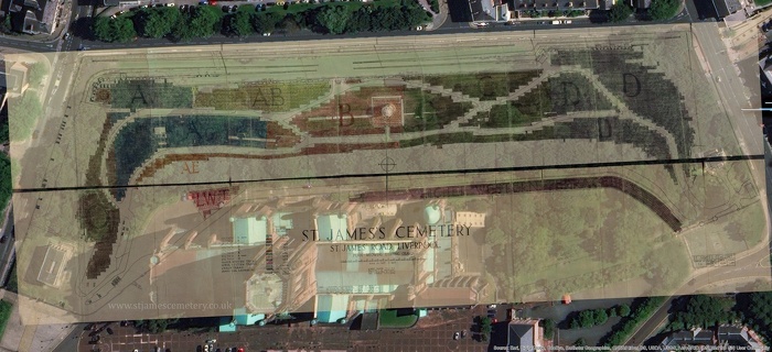
Plan of Graves, 1926
© Please do not reproduce this image.
Click here to view full-size.
This is the full plan of the cemetery drawn by Gilbert Fraser in 1926 overlaid on a modern satellite map of the area. It shows all grave plots surveyed in 1926, but only the number and section, not the name. Currently, to find a plot number it is necessary to consult the burial records.
Section Av is coloured blue-green and contains approximately 286 graves. It is comprised of the vaults of the north-eastern (top left) section of the cemetery.
Section Ag is coloured blue and contains approximately 980 graves. It is comprised of the majority of the northern (left) section of land bounded by pathways on all sides.
Section B contains approximately 918 graves and is coloured in red. It is comprised of Huskisson's monument and the land to the north (left), as well as to the west (bottom) between the mount and pathway.
Section C is coloured in dark green and contains approximately 1404 graves. It is comprised of the land between the ramps and mount to the south (right) of Huskisson's monument until its border with section D.
Section D is coloured grey-blue and contains approximately 1867 graves. It is comprised of the southern (right) section of the site, and is bounded by the public (unmarked) section of the cemetery at the far south.
Section AB is coloured yellow and contains approximately 508 graves. It is comprised of the area along the east wall and is bounded by the pathway to the west (bottom), well/spring to the south (right), and section Av to the north (left).
Section AE is coloured orange and contains 147 graves. It is comprised of a small narrow section of land running parallel to the mount, bounded by the pathway to the east (top).
Section O is coloured grey-brown and contains approximately 678 graves. It is comprised of the north (left) section of the site.
The Higher Western Terrace is coloured purple and contains approximately 628 graves on the higher ground of the mount, in front of the cathedral site today.
The Lower Western Terrace is coloured pink and is a small triangle of land containing approximately 101 graves. It is part of the higher ground of the mount outside the north-east corner of the cathedral today.
